GPS Boundary:
This area is bounded by straight lines connecting the following points in the order listed except where noted:
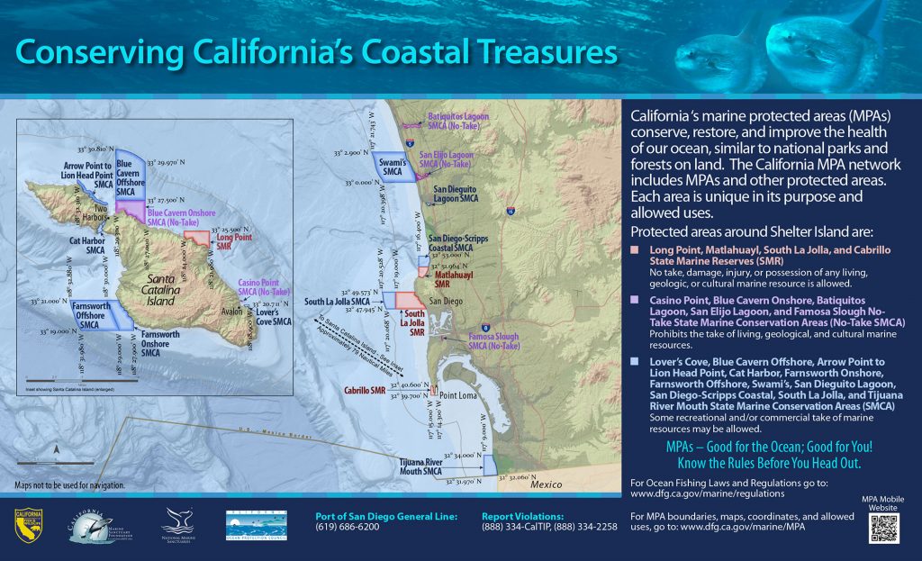
32° 49.573′ N. lat. 117° 19.000′ W. long.;
32° 49.573′ N. lat. 117° 20.528′ W. long.;
thence southward along the three nautical mile offshore boundary to
32° 47.945′ N. lat. 117° 20.068′ W. long.;
32° 47.945′ N. lat. 117° 19.000′ W. long.; and
32° 47.945′ N. lat. 117° 19.000′ W. long.
Permitted/Prohibited Uses:
- Recreational Fishing:
- Allowed Species: Pelagic finfish by hook-and-line only.
- Prohibited Species: All other living marine resources EXCEPT those listed above.
- Commercial Fishing:
- Allowed Species: None
- Prohibited Species: All
- Definitions:
- Pelagic finfish, for the purpose of this section, are a subset of finfish defined as: northern anchovy (Engraulis mordax), barracudas (Sphyraena spp.), billfishes* (family Istiophoridae), dolphinfish (Coryphaena hippurus), Pacific herring (Clupea pallasi), jack mackerel (Trachurus symmetricus), Pacific mackerel (Scomber japonicus), salmon (Oncorhynchus spp.), Pacific sardine (Sardinops sagax), blue shark (Prionace glauca), salmon shark (Lamna ditropis), shortfin mako shark (Isurus oxyrinchus), thresher sharks (Alopias spp.), swordfish (Xiphias gladius), tunas (family Scombridae) including Pacific bonito (Sarda chiliensis), and yellowtail (Seriola lalandi). *Marlin is not allowed for commercial take.
Effective as of: January 1, 2012
Additional Resources:
- Fishing Guide San Diego MPAs (346K PDF file)
- Marine Recreational Brochure San Diego MPAs (749K PDF file)
- San Diego Regional Map (3.5M PDF file)
- San Diego Harbor Sign