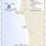
GPS Boundary:
This area is bounded by straight lines connecting the following points in the order listed except where noted:
41° 52.000′ N. lat. 124° 23.189′ W. long.;
41° 52.000′ N. lat. 124° 25.805′ W. long.;
thence southward along the three nautical mile offshore boundary to
41° 49.000′ N. lat. 124° 26.252′ W. long.;
41° 49.000′ N. lat. 124° 23.189′ W. long.; and
41° 52.000′ N. lat. 124° 23.189′ W. long.
Permitted/Prohibited Uses: *
- Recreational Fishing:
- Allowed Species: Salmon by trolling; and Dungeness crab by trap
- Prohibited Species: All other living marine resources EXCEPT those listed above.
- Commercial Fishing:
- Allowed Species: Salmon with troll fishing gear; and Dungeness crab by trap.
- Prohibited Species: All other living marine resources EXCEPT those listed above
* The following federally recognized tribes (listed alphabetically) are exempt from the area and take regulations for Point St. George Reef Offshore State Marine Conservation Area (subsection 632(b)(2)) and shall comply with all other existing regulations and statutes: Elk Valley Rancheria and Tolowa Dee-ni’ Nation
Effective as of: December 19, 2012